Precisely Streets

Robust street-level data for mapping, analysis, routing, and geocoding

Talk to an expert

Spatially accurate mapping framework

Precisely Streets is comprised of multi-sourced, topologically correct datasets for over 200 countries and territories around the world. Products include fully attributed vector datasets with street, address, transportation, land use, water feature, and points of interest information. Multi-scale basemaps are designed to interact with these vector datasets for detailed geographic analysis.

Streets, roads, and highways are provided in a classified hierarchy for clarity and consistency. Simplified chained networks accelerate map rendering for display purposes and more efficient workflows.

Detailed, interactive, editable, and searchable, Precisely Streets data is designed for use right out of the box with relevant and accessible content. Frequent updates keep datasets fresh and ready to use for highly accurate, detailed analytics.

Precisely Data Experience: Precisely Streets

Precisely Data Experience lets you sample our datasets for free – Try it now!

Mapping

Visualize and profile street networks, speed limits, and vehicle restrictions

Analyze icon

Analysis

Analyze your data against street usage and surrounding features

Car symbol

Routing

Calculate drivetimes and determine the most efficient way to travel

Geocoding

Pinpoint addresses on a street network map for more accurate analysis

Easy integration and flexible formats

Supplied in industry-recognized file formats for quick and painless integration within desktop and enterprise environments, Precisely Streets datasets allow you to fully realize the benefits of location intelligence as part of your integrated business processes. You can get actionable insights faster by streamlining installation across states, countries and continents with a global installer.

Precisely Streets datasets organize, simplify, and derive key attributes and content from multiple sources to provide the right content in the right format for your organizational needs.

Supports critical decision-making

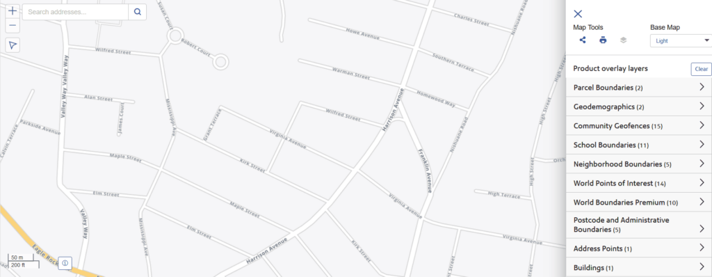
Precisely Streets provides vital information for decision-making for multiple industries, including  insurancetelecommunicationsretailfinancial services, and more.

Street network data and basemaps provide integral insight into logistics planning, asset management, risk mitigation, fraud analysis, customer research, retail planning, and emergency preparedness.

Perform fraud and risk analysis by locating customers, incidents, and areas of risk, and revealing geographic relationships.

Analyze and plan access to telecommunications networks, emergency services, and public transportation.

Create retail catchment zones by understanding how far customers can drive in a set amount of time, as well as relative traffic levels throughout the day.

Explore our Data Guide

Discover our complete portfolio of streets datasets

View our datasets

Additional Resources

According to this research report by Harvard Business Review Analytic Services, companies are rethinking data-driven practices for today’s digital market.
RC-Analyst Reports

Harvard Business Review: Changing the Rules of Data

Defining digital audiences with data
RC-Webinars

Defining Digital Audiences with Data

Analyzing Streets, Traffic, and Drivetimes in MapInfo Pro
RC-Webinars

Analyzing Streets, Traffic, and Drivetimes in MapInfo Pro

Request a demo of Precisely Streets