MapXtreme

Build geospatial applications that empower your business with this complete software development kit (SDK)

Request a demo

Enhance business analytics

Location is a part of everything we do. With location-based business data on the rise, the demand for applications containing location intelligence capabilities is high. The challenge for developers is obtaining development tools to help them incorporate meaningful and flexible location analytics into existing workflows.

Integrate spatial analytics into day-to-day business operations with custom geospatial applications using MapXtreme’s powerful Software Development Kit (SDK).

  • Make more informed business decisions
  • Improve customer services
  • Augment facility and asset management
  • Increase organizational responsiveness
The one-stop spatial SDK

As a .net developer, being able to access a range of functionality from one SDK increases productivity. With MapXtreme, key spatial tools are included, enabling you to automate location-based processes, perform geometric and raster analysis, and create visualizations.

Experience consistency across both desktop and server web development, sharing and re-using code between deployment types. MapXtreme software supports Open Geospatial Consortium (OGC) standards. Facilitate rapid development of web applications for all web deployable .NET languages and benefit from features including:

  • WMTS client support
  • WFS 2.0 server/client support
  • Vector layer opacity
  • Performance improvement for file servers
  • Support for more than 250 fields in a table
Reduce time, increase power

Reduce your development process with development templates, sample programs, toolbars, and dialog boxes. MapXtreme’s drag-and-drop functionality and intuitive tools make it easy to add data and spatial capabilities efficiently.

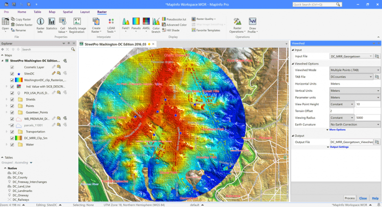
When you require high performance with extremely large raster and grid datasets, MapXtreme Advanced provides it. This SDK takes advantage of the Multi Resolution Raster (MRR) data storage format, to deliver high quality raster visualization and analysis with extraordinary speed and precision. For example, you can map and analyse huge datasets with extraordinary processing speed across states, countries and even continents.

Raster and grid data analysis functionality includes:

  • Reprojection
  • Interpolation
  • Inflection points
  • Hill-shade support
MapXtreme
Deliver high quality raster visualization through the MapXtreme SDK.

Benefits

Fully equipped
Contains the core components needed to build custom location analytics applications and automate workflows
Flexible applications
Employ templates, sample programs, toolbars, and dialogue boxes that make it easy to add geospatial capabilities
Productive deployment
Efficient sharing and re-use of code and knowledge between desktop and server deployment
Performant analytics
Process large volumes of raster data for advanced location analysis with extraordinary speed and precision

Want to learn more?

Artboard 1 copy 56

Solution Sheet

MapXtreme

Download
Artboard 35

Analyst Report

Location Intelligence: The Data-Driven Paradigm Shift

Download
Artboard 1 copy 23

Customer Story

BT Group Puts Location-Based Technology from Precisely to Work Across the Enterprise

Download

Request a demo of
MapXtreme

This site is protected by reCAPTCHA and the Google Privacy Policy and Terms of Service apply.