
The concept of taxation can be seen throughout history and dates as far back as the ancient Egyptians. Both the Greeks and the Romans were known to excise taxes on the sale of goods, and other types of taxes were known to be levied by the Aztecs, Inca, and ancient civilizations in China and Japan. Today’s tax codes are much more complex than those of the past and understanding which types of taxes in what amounts apply to which specific transactions can be difficult at best. Advanced geocoding technology can help.
Highly accurate, location-based tax assessment is making it easier than ever for businesses to assess the right amount of tax to charge based on a clear understanding of Federal, State, and local tax laws combined with precise location information.
Calculating tax jurisdiction is difficult
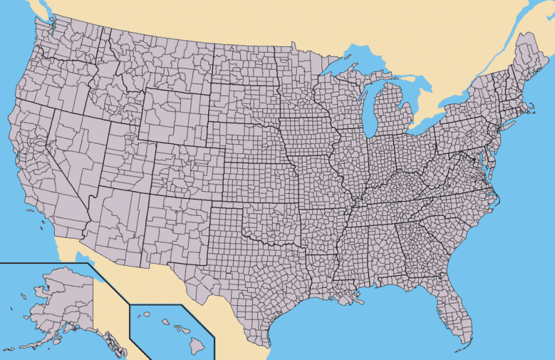
In the United States, as in many countries, tax jurisdictions are not always aligned with the boundaries that are used to define regions of political responsibility or areas and points of deliverability for entities like the postal service, UPS, and FedEx.
ZIP Codes, while one of the main means by which businesses assess tax, are insufficient because they are designed for delivering mail, often don’t align with taxing jurisdictions, and shift with jurisdiction assignment changes.
In fact, nearly 30% of US ZIP Codes are in conflict with municipal, county, and state boundaries. Even ZIP+4 is only designed to assign a delivery route to a piece of mail and does not necessarily result in a more accurate understanding of an address’s location with regards to taxation.
Combine this with constantly changing boundaries, an increasing number of tax districts, and the addition and expiration of tax mandates at every level and you can see why it is so difficult to obtain accurate tax rates for any given location.
Advanced geocoding is making tax assessment easier
Two important areas of advanced geocoding are making tax assessment easier: municipal boundaries and special purpose districts.
Municipal boundaries
Municipal boundaries are political lines that designate the physical limits of a town, city, borough, or its local government. Many times these boundaries are the basis for local taxation, and represent taxes that are levied below the Federal and State level.
It is estimated that there are upwards of 4,800 changes to municipal boundaries every single year and ensuring that the most accurate and up-to-date municipal boundaries are being used in tax assessment is a critical first step to ensuring accurate results.
Advanced geocoding technology today allows businesses and developers of tax assessment applications to easily update municipal boundary data as soon as changes are made. This data is aggregated from a number of different sources including Secretaries of State, State Tax Boards, Planning and Boundary Commissions, and State-level Departments of Revenue and Transportation. All this data can be brought together into a single dataset that gives an accurate overall picture of the current state of municipal boundary location.
Special purpose districts
Special districts in the United States are independent, special-purpose governmental units that exist separately from local governments and operate with a large degree of administrative and fiscal independence.
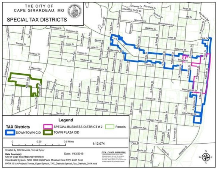
Special districts do not conform to municipal or other boundaries and are difficult to navigate because they can cross ZIP Codes, can exist within only a portion of a ZIP Code, may consist of multiple disconnected regions, can be overlaid on top of one another, and can change frequently.
While information regarding the creation, existence, and retiring of special districts and their tax rates is public knowledge, technology allows us to more readily aggregate all of this information into single datasets that can be queried to provide this information to vendors and purchasers of goods and services to assess the correct tax rate for any given sale. Advanced geocoding technology is making it easier than ever to accurately assess tax rates no matter where you or your purchaser/seller are located.
Find instant accurate local tax rates that apply to your needs
Today’s tax codes are much more complex than those of the past. Highly accurate, location-based tax assessment is making it easier than ever for businesses to assess the right amount of tax to charge based on a clear understanding of Federal, State, and local tax laws combined with precise location information. See how advanced geocoding technology is being used to get more accurate tax rates.
Location, location, location
While technology has made it infinitely easier to understand the extent of taxation boundaries and the actual rate of taxation, this does “no good” if you aren’t able to accurately place a given address within a specific boundary.
As noted above, using a ZIP Code or even a ZIP+4 is going to put your point in the center of your ZIP Code (or ZIP+4) which is an arbitrary place relative to its actual location. While this may be OK for Federal and State tax rates that are levied at a geographic scale larger than a ZIP Code, it has absolutely no place being used to assess local or special district tax rates.
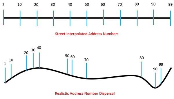
Even street interpolated locations might not be enough to get tax rates right in many instances. Street interpolated data assumes that addresses are evenly spaced along a street segment, when reality often proves that this is not the case.
This is extremely important when streets cross special district, municipal, or county lines where taxation rates are different. Many streets cross state lines were individual parcels are bisected, and the placement of the structure on the parcel determines the tax jurisdiction!
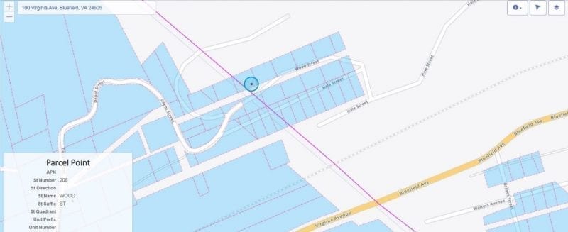
In cases such as this, only point-level data will give you the accuracy needed to calculate an accurate tax rate. Datasets are now available for many countries that provide rooftop-level accuracy for millions of addresses, and access to this highly valuable data is beginning to be offered through applications and APIs to businesses worldwide at cost effective rates.
While the tax code has become infinitely more complex since the days of ancient Egypt, technology has come a long way in simplifying the process of calculating accurate tax rates for the modern age. The ability to aggregate and update millions of data points around ever-changing boundaries, tax rates, and jurisdictions makes it simple for small businesses to stay up to speed in the nebulous world of tax codes.
Combine this with pinpoint accuracy when it comes to placing addresses within those jurisdictions, and you begin to see simple, easy to use tax applications that put all of this technology directly into the user’s hands.
GeoTAX is an easy-to-use web application that helps vendors of taxable goods and services instantly assess local tax rates. Visit GeoTax to learn more.