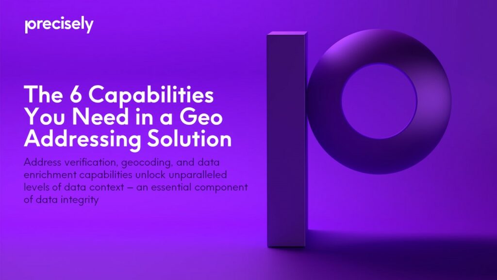
LOCATION INTELLIGENCE & DATA
Geo addressing, geocoding, and data enrichment solutions
Better understand customers, properties, businesses, and competitive landscapes thanks to accurately verified, geocoded, and enriched addresses that deliver relevant context.
Unlock the keys to context
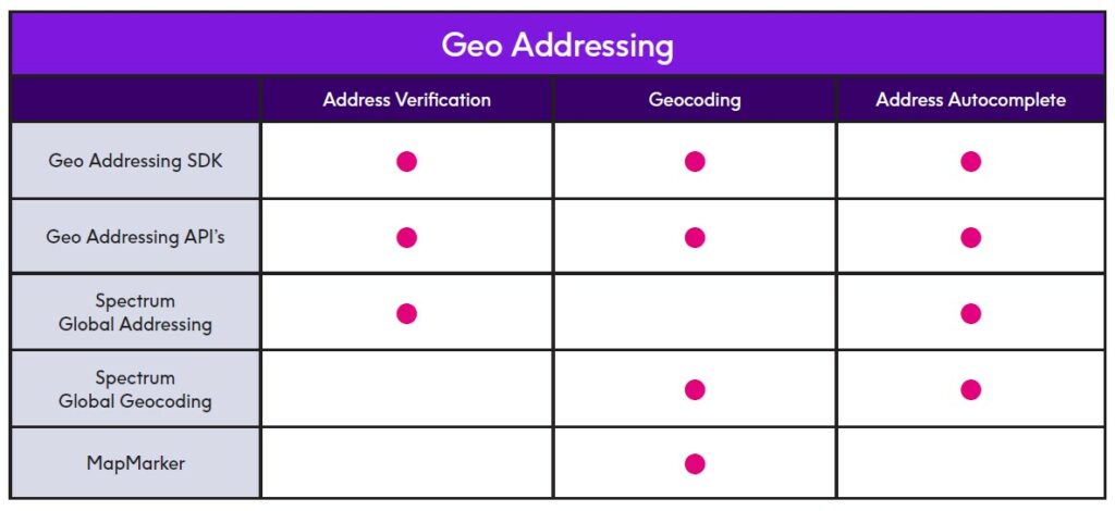
Precisely geo addressing solutions helps simplify working with addresses:
- Parse, standardize and match addresses with address verification.
- Associate a latitude/longitude coordinate to each address with address geocoding.
- Look up addresses with ease and efficiency with address autocomplete.
Location context for analytics
Whether business users are working in enterprise applications, business intelligence (BI) and analytics dashboards, or Precisely’s industry-specific applications, they need information with context.
Context is an essential element of data integrity – without it, address data becomes one of the most challenging types to work with.
And considering the value to be found within this information, an organization’s utilization of address data should be truly seamless.
That’s where geo addressing comes in.
Leveraging best-in-class address verification, geocoding, and data enrichment capabilities, it ensures that business addresses are verified, standardized, and cleaned for maximum accuracy – delivering trusted, contextualized data when and where it’s needed.
Let’s break down the components of geo addressing – and what they empower you to accomplish:
Address verification: match an address against reference data to confirm validity and deliverability, then standardize it to local postal standards.
Location intelligence (LI): identify connections between geographic places and what exists or occurs there. But before these connections can be made, you need to accurately geocode each address.
Geocoding: assign hyper-accurate location coordinates and attach a unique and consistent identifier, the PreciselyID, to each address. Using the PreciselyID to operationalize an address, you can begin to analyze and enrich the data for even more powerful insights.
Data enrichment: connect your addresses with Precisely’s data enrichment catalog of over 400 datasets containing more than 9,000 attributes.
Data enrichment delivers the context necessary to create data-driven strategies. Whether you’re interested in standard data (like points of interest and property attributes), or dynamic data (like demographic movement and weather changes over time), you can enrich your enterprise data with relevant context – such as finding out who lives nearby, in which neighborhood, and stores within a five-minute walk.


Manage and enrich address data
There’s no question about the importance of address-matching software – it’s a critical component of location master data management. But it’s equally important to remember that these tools always come with a margin of possible error.
That’s why a unique identifier is key.
Just like a fingerprint removes ambiguity about a person’s identity, a unique identifier resolves questions about a location. It provides an accurate and consistent view of an address and facilitates linking that address across systems or joining new datasets.
The PreciselyID fits that bill. You’ll find it attached to our address datasets, and to business addresses within our geo addressing solutions.
What exactly does that mean in action? It means that alias address records aren’t counted as duplicates when address strings change; that when a street name or postal code changes, the PreciselyID remains consistent – leading to more accurate analytics.
The PreciselyID is also used in data enrichment to quickly obtain contextual information about an address.
Appended to millions of data points, it links an address to points of interest, property, demographic, and boundary datasets. Performing a quick and straightforward lookup of a PreciselyID returns a variety of rich information related to that specific geocoded record.
Precisely’s tools help you manage and organize business data to bring greater location context to your analysis.
For example, with geo addressing and enrichment capabilities you can quickly understand whether an address falls within a flood zone or an affluent area – no point-in-polygon operation required.
The unique and persistent nature of the PreciselyID facilitates seamless interoperability between datasets for data enrichment.
Joining different datasets together empowers you to analyze an address from multiple perspectives and eliminate time-consuming spatial processing.
Strengthen marketing investments
To identify target markets, you start with location.
Geocoding a store’s address gives you an accurate point for understanding service areas and conducting drive time or distance analyses. For example, you can locate who lives nearby or frequently travels to the area to define your target market. This location intelligence can help you identify where you should focus your marketing efforts to keep those investments secure.
Data enrichment takes things a step further.
For advanced customer analytics, a valid address can be linked to detailed household, income, and dynamic demographic data. That gives you the confidence to not only locate a prospect, but to get a complete, accurate picture of their world.
These insights can help you build compelling marketing messaging, products, and services for your target markets.


Improve customer experience
Consumers expect companies to understand who they are and develop customized offers and messages – this becomes increasingly important as the digital landscape continues to shift and competition becomes more fierce.
Geo addressing customer data can help reveal patterns that inform these strategies. Knowing where someone is located can help you determine defining characteristics about them.
For example, locating a customer’s home address in a neighborhood of predominantly Spanish-speaking households might prompt you to send them a coupon in Spanish. Or, identifying that your customer’s daily commute passes by your store may lead you to send them special mobile offers.
A tailored experience is also essential to several of your other business needs.
More relevant address suggestions empower confidence in your decisions. You’ll be able to capture the correct address in real-time thanks to smart autocomplete features that return a suggested list of complete addresses, based on partial address keystrokes – useful for any local search, checkout, shipping, or billing experience on your website.

Precisely Achieves FedRAMP® Certification
for its Data Integrity Suite Data Governance Service and Geo Addressing API
Accurately assess risk
Determining a property’s proximity to hazards can help prevent under- or over-priced insurance policies.
Rooftop-level geocodes provide the most accurate way to measure property risk, enabling you to analyze the structure itself in relation to the hazard. By building models with accurate geo addressing and enriched datasets, you’ll also find that you’re winning back time to focus on high-value analytics – thanks to the reduction of time spent on data cleansing.
Accurate risk assessment is also vital to public safety and emergency response. When officials understand a community’s exposure to natural hazards, they can take on a more proactive approach to better plan for and mitigate catastrophes.
Enriching geocoded locations with information related to fires, floods, and earthquakes identifies where preventative measures should be taken, while measuring proximity to emergency services can indicate where resources should be allocated.
Analyzing risk through data enrichment is also increasingly important to potential home buyers.
Consumers want to do their due diligence and know everything they can about a given property. This process, after all, results in the most significant financial decision of their lives. Understanding the specific risk profile of a property is a powerful tool in making informed real estate and investment decisions.

Adding value to location
Leveraging address data to inform business decisions is something that should be simple and seamless, especially considering how much value there is to be gleaned from it.
And yet, it’s an extremely complex and ever-growing challenge, especially across multiple countries and address formats. For trusted, transformative results, you need deep domain expertise that delivers the best possible address match and hyper-accurate location coordinates.
Geo addressing provides the greatest lift to your business strategy when highly accurate matches allow you to operationalize an address. Properly cleaning, standardizing, and validating an address ensures it can be located appropriately and enriched with the information you need to make critical decisions.
That’s why Precisely offers the most accurate global geo addressing solution for over 250 countries and territories. We’ve accomplished this by consolidating the capabilities from our world-class geocoding and address verification software into a single, powerhouse solution that provides the flexibility to meet your own unique needs.
Choosing a flexible solution now will save yourself potential headaches and unexpected costs later. It’s important to keep in mind that as your business evolves, so will your IT needs and capabilities. On-premises geo addressing should be easy to embed into server and desktop applications, and cloud-based solutions should offer the same results and rich capabilities as on-premises options.
Ultimately, it’s the crucial component of context that builds data integrity and sets your business apart from the competition – fueling optimized business processes, product innovation, and deeper insights into customer preferences and behavior for more informed decision-making and marketing personalization.
That’s why we make context-filled data available through virtually any access method – like queries, visualizations, API calls, or Data as a Service for data pipelines. It’s all about meeting your business where it’s at, and making sure that your journey is successful.
Precisely’s data enrichment and location intelligence capabilities empower you to ensure your data is trusted and rich in context, when and where it’s needed most.