MapInfo Pro

A location intelligence solution that turns data into decisions.

Powered by Precisely data. Simplified by AI.

Request a demo 30 day free trial

Benefits

Complete solution

Most teams waste time jumping between tools.

Bring location data management, analysis, and visualization together in one place so your GIS team moves faster, and your business gets answers sooner.

Mapping and Analysis, Made Easy with AI

Complex GIS workflows slows everyone down. 

Use MapInfo Pro’s AI assistant to build maps and run spatial analysis using your own and trusted Precisely data in a fraction of the time.

Built for Complex Data

Most GIS tools slow down under the weight of large spatial datasets.

MapInfo Pro’s patented Multi-Resolution Raster format processes and renders even the largest raster datasets without compromising speed or accuracy.

Scale With Confidence

As your business grows, your location intelligence should too.

MapInfo Pro scales with your organization, bringing the full power of Precisely data wherever your business needs it.

Use MapInfo Pro for:

Analyze icon

Risk Analysis or Site Selection

Choosing the right location or avoiding the wrong one is one of the most consequential decisions a business makes. MapInfo Pro combines your internal data with trusted, AI-ready Precisely location data to model risk, evaluate sites, and surface the insights that make the decision clear before you commit.

Checklist icon

Field and Operational Planning

When your work happens in the field, every routing, territory, and resource decision has a direct cost. MapInfo Pro brings location intelligence to operational planning, so your teams spend less time figuring out where to go and more time doing the work that matters.

Pie chart icon

Reporting and Stakeholder Communication

Location insights only create value when the right people can act on them. MapInfo Pro turns complex spatial analysis into clear, visual web maps and reports that anyone in the business can understand, so decisions get made faster and with greater confidence.

Context layer for AI

Work With Location Data Using AI

MapInfo Pro’s AI assistant lets anyone ask questions in plain language, automate mapping tasks, and surface insights from even the most complex location datasets, so your whole team moves faster.

Shape

With the network changing and developing rapidly, up to-date network information is vital to guarantee quality and stability to our existing customers and prospects.”

See their story

Arian de Korte, Operations Director

eurofiber

Bring a new dimension to your spatial data

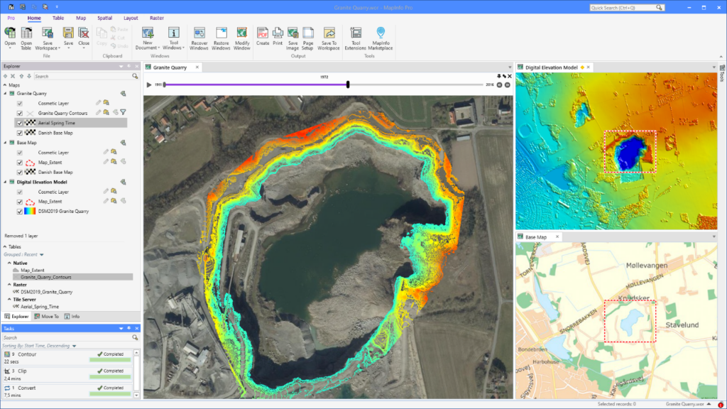
We live in a 3D world, so visualizing three-dimensional spatial data provides a more comprehensive and realistic representation of terrain, buildings, and objects.

Some applications – like disaster management, coastal modeling, and urban planning – will rely entirely on your ability to create realistic digital representations. And 3D visualizations offer a more intuitive and immersive view of geospatial information, making it more accessible for non-GIS teams.

With MapInfo Pro, you can easily visualize your 3D data using OpenGL rendering without additional tools or extensions. Quickly display data in 2D and 3D simultaneously to reveal patterns and relationships not seen in traditional visualization, then share your findings with broader teams for greater impact.

Unlock the next dimension in spatial analytics

Why Telecommunications Companies Need to Ensure Compliance to Maintain Federal Funding

Supercharge telecom service upgrades with MapInfo Pro

Watch the demo

Time series analysis of granite quarry extraction

Extract information from raster data

Creating optimum insights from large spatial files can be a significant challenge. Use our patented Multi-Resolution Raster (MRR) data format for powerful spatial processing and map rendering. Identify, quantify, and visualize spatial patterns in raster datasets of practically unlimited size. Or use our Multi-Resolution Virtual Raster (MVR) to virtually merge, reproject, and resample raster grid data on-the-fly, without writing out new grid files to disk.

Simplify spatial data workflows with cloud support

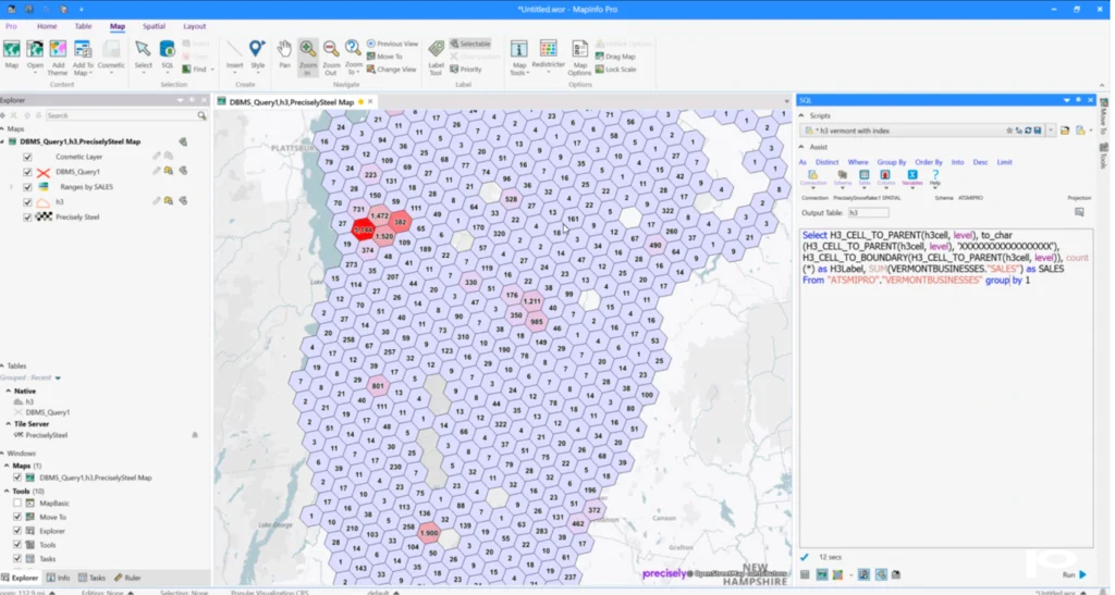
Connect to the Snowflake Data Cloud to access, edit, visualize spatial data, and create maps effortlessly. Get the maximum value from your spatial data while enjoying the scalability, flexibility, and performance of the modern cloud. Choose between live connections or offline subsets to fit your workflow. With smart filtering, caching, and server-side processing, you’ll work faster and more efficiently—even with large datasets.

Reveal trends and patterns by visualizing aggregated data using H3 hexagons

Seamlessly connect to trusted AI-ready datasets and spatial APIs

MapInfo Pro connects directly to the Precisely Data Integrity suite to bring location, property, and risk intelligence into every analysis without leaving your familiar workflow.

From identifying optimal site locations to assessing risk exposure, your teams move from map to decision faster and with greater confidence.


Python and MapBasic Support

Increase productivity by building, running, and reusing customized applications. MapInfo Pro offers robust support for MapBasic and Python scripting languages.

Geocode and Drivetime

Take advantage of best-in-class geocode and drivetime analysis directly within the MapInfo Pro interface.

MapInfo Pro Viewer

Drive collaboration within your enterprise with the free MapInfo Pro Viewer. It allows line of business users to open any MapInfo workspace. Open tables in read-only mode and perform basic map operations such as pan, zoom, or reordering layers.

The GIS you trust — now a subscription service

Maintain your GIS edge with a MapInfo Pro subscription. You’ll enjoy a reduced price while automatically receiving:

  • 1-3 year subscription options
  • Continued support for web-based data services, including Bing imagery
  • Access to the latest MapInfo Pro software updates and upgrades
  • Expert support via phone, chat, and email

Explore MapInfo Pro free
for 30 days


Shape

As a MapInfo Pro user for three decades, it has been my sole GIS mapping tool. The interface is easy to use and very powerful. Reducing file sizes with the Multi-Resolution Raster (MRR) format has dramatically helped to open and display large datasets. For those projects where you need to see data changes over time, the time series feature is impressive.”

Lynn Bryant, Director of Spatial Transformation and Automation

Bryant Solutions

Want to learn more?

MapInfo Pro v2023
Solution Sheet

MapInfo Pro v2023

Location intelligence
Analyst Report

Location Intelligence: The Data-Driven Paradigm Shift

Domino’s Pizza streamlines franchise planning using Location Intelligence
Customer Story

Domino’s Pizza Streamlines Franchise Planning Using Location Intelligence

Request a demo of MapInfo Pro

Fill out the form and one of our experts will be in touch.

Frequently Asked Questions

MapInfo Pro is a desktop GIS and web mapping platform that helps teams manage, analyze, and act on location data. It helps GIS analysts and business teams manage, visualize, analyze, and publish location data, combining trusted Precisely data with your own to surface the patterns, relationships, and trends that drive better decisions.


MapInfo Pro is built for organizations that need powerful GIS capabilities without the complexity or cost of traditional enterprise platforms. It includes an AI assistant for natural language spatial analysis, native web mapping, and direct access to Precisely data, making it faster to deploy and easier to use across the whole business, not just the GIS team.

Yes. MapInfo Pro includes patented Multi-Resolution Raster (MRR) technology purpose built for processing and rendering large spatial datasets of practically unlimited size, without slowing you down. For even greater flexibility, the Multi-Resolution Virtual Raster (MVR) format lets you merge, reproject, and resample raster grid data on-the-fly, without writing new files to disk.

Yes. MapInfo Pro includes an AI assistant that lets anyone complete common mapping and spatial analysis tasks using natural language. No GIS expertise required. It connects directly to trusted Precisely data so teams can move from question to insight faster.

MapInfo Pro is used by GIS analysts, data teams, operations leaders, and business decision makers across government, insurance, utilities, telecom, retail, and logistics.

MapInfo Pro supports web mapping, spatial analysis, site selection, risk modeling, field and operational planning, and stakeholder reporting — all in one platform, powered by Precisely data and your own.

MapInfo Pro connects directly to the Precisely Data Integrity Suite, giving users access to trusted location, property, risk, and demographic datasets through spatial APIs, without leaving their familiar workflow.

Yes. The AI assistant simplifies complex GIS workflows so business teams across the organization can access and act on location intelligence without needing specialist expertise.