
The value of data continues to grow as the volume of available information increases and data analytics platforms become more performant. For many companies, there is a strong case for making location intelligence integral to everything they do. By enriching existing data with geospatial location intelligence, companies can gain a better understanding of their customers, assets, existing and potential locations, and much more.
Often, companies can add significant value with just one or two elements of geospatial data within a larger business process. By leveraging geospatial application programming interfaces (GeoAPIs), developers can quickly and easily incorporate location information in a variety of ways. Consider a few examples, beginning with an example from the world of property insurance.
Property risk mitigation
Consider the many factors that come into play if you were an underwriter assessing the likelihood of a loss on a specific property due to fire. You might want to know how far the property is from the nearest fire department facility. You would probably like to see if there is a hydrant nearby, or if the fire department would need to depend on a natural water source such as a nearby pond. You would want to know how far away that pond is from the property, and whether or not it is dry at certain times of the year. Finally, you would like to know the property’s proximity to combustible materials such as dry timber or brush and the likelihood of widespread fires in the area.
If you were able to apply scoring criteria to each of these factors to assess risk, then the process of computing an overall score would become a relatively straightforward mathematical proposition.
By making a programming call (that is, by writing a few lines of code that make an information request to the GeoAPI), a software developer can automate the process of gathering all the data needed to calculate a risk assessment score for the property.
That’s the magic of working with GeoAPIs; it can quickly, easily, and flexibly automate the retrieval of geospatial data as part of a larger business process.
Precisely APIs
GeoAPIs from Precisely provide companies with a simple and flexible way to embed geospatial information into applications and business processes. Visit us to learn more about Precisely APIs and access a free trial.
Demographic profiles
Let’s look at a second example in which a firm specializing in site selection for retail businesses wants to be able to quickly and easily understand the demographic makeup of the areas in which it is searching. If the population of a particular trade area includes a large number of college students, then it might not be the most suitable location for businesses that cater primarily to retired people, for example.
In this case, a developer can write code that makes a programmatic request for demographic information based on a specific address. If the data source that is accessed through the GeoAPI is sophisticated enough, then it can provide highly nuanced information. For example, if the daytime population of an area consists of a large number of office workers commuting from nearby suburbs, then an accurate demographic profile should reflect that. Otherwise, the firm would have an incomplete picture of its prospective new store location.
With APIs that have been built around a sophisticated and nuanced geospatial dataset, the site-selection company can access highly accurate and useful information about any of its prospective properties in just moments.
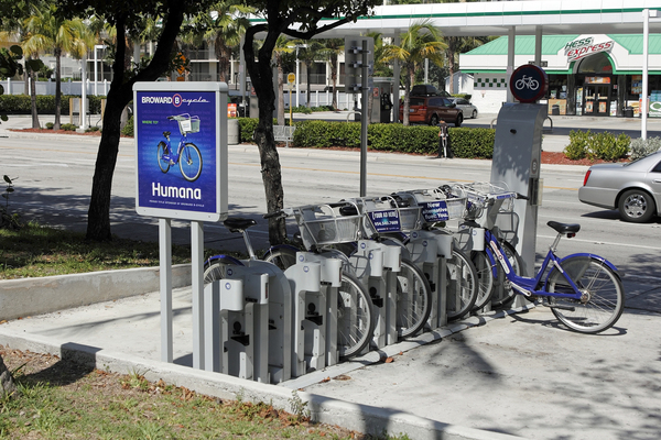
Find the nearest…
In the past few years, many cities have added bike rental kiosks at various locations around town. Someone who wants to rent a bike can simply pick one up at an automated kiosk and return it to a different location. Let’s consider what might happen at a time when demand is high for bike rentals. As a visitor to the city, you would like to know where the nearest kiosk is located, but you don’t want to be directed to a location that no longer has any bicycles available.
A developer could build a mobile app that retrieves information about available bikes, their locations, and your proximity to them. It could even allow you to reserve a bike so that it still there when you arrive. By using a GeoAPI along with sensor information from the bike rental kiosks, developers can provide their mobile app user with information about the nearest rental location that still has bikes available.
This is a simple example of how a specific need for geospatial information can be addressed within the broader context of an application or business process (in this case, matching a potential customer with the most convenient available inventory).
 Maximizing returns on renewable energy investments
Finally, consider a scenario in which installers of residential photovoltaic energy systems would like to be able to calculate how much energy would theoretically be produced by a new system. There are a number of factors that go into that equation, including the latitude at which the property is located, the exact direction that the panels will face, and the average sunlight exposure in the region.
At least two of those three data points could be provided by programmatic calls to GeoAPIs that are built on top of a sophisticated pool of geospatial data. Depending on the nature of the installation, GeoAPIs could potentially even provide all three data points (for example, if you can programmatically discover the exact direction that a home is facing).
For a developer, the GeoAPIs can do the heavy lifting of extracting the geospatial variables that pertain to a specific property. All that is left to do is to plug those values into a solar energy equation.
Virtually every available data point in the world has the potential for some element of location to be attached to it. With a vast array of geospatial data now available, GeoAPIs have made extracting that information and making it available within an application or business process easier than ever.
GeoAPIs from Precisely unlock a world of new possibilities for companies to embed location information within business processes.
Learn more about Precisely APIs and a free trial.