Customer Story
San Bernardino County Increases Fire Resiliency with Pro Bono Wildfire Risk Data from Precisely
![]()
2.2 million
San Bernardino County residents
20,105
square miles of land mass
93%
of homes identified as “at-risk”
With access to accurate and reliable data, San Bernardino County Fire Safe Councils can secure grants, improve Community Wildfire Protection Plans, and help manage risk to property and citizens
Introduction
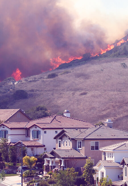
Often referred to as the “Golden State,” California is known for its beautiful coastline and beaches, desert area, and mountainous region. These days, however, it’s becoming increasingly associated with the threat of wildfire, with yearly statistics showing that over two million residential properties in the state are consistently identified as “at-risk” of wildfire damage. As the effects of climate change evolve, the wildfire season in California continues to lengthen and increase in severity. In 2020, wildfires damaged 4.2 million acres of land and were the cause of death for at least 31 people. Two years later, the wildfire season began in January in San Bernardino County, California – an unusually early start – which was an indication of the length of the season ahead.
Several factors lead to wildfires, whether it’s a result of the region’s climate and terrain, or ignition sources left by residents. When the two are combined, the risk of wildfires increases exponentially, which is why having a Community Wildfire Protection Plan (CWPP) that identifies and prioritizes areas for hazardous fuel reduction treatments and provides resources on fire resiliency is critical to the health and safety of communities. A CWPP addresses wildfire response, hazard mitigation, community preparedness, and structure protection issues.
San Bernardino County has the largest land mass of any county within the United States, covering a total of 20,105 square miles and home to nearly 2.2 million residents. Within this surface area, 93 percent of the land is part of the Desert Region, and 2.5 million acres is recreational. Unlike many other recreational destinations within the state or even country, 10 percent of the nation’s population is within a 90-minute driving time throughout the year. In Joshua Tree, for example, there are more tourists in the area at any given time than there are residents. Due to the County’s high tourism population, and many rural residential neighborhoods, the risk of wildfires caused by ignition sources is higher than usual.
Therefore, the Fire Safe Councils (FSCs) within the County rely on CWPPs to ensure all citizens are educated on fire resiliency and have safety protocols in place. Being that CWPPs are a public service to citizens, the FSCs are reliant upon public grants to fund these protocols, making the grant applications highly competitive.
![]()
Overview
- Located in San Bernardino County, California, USA
- Largest county in the contiguous U.S. in land mass
- 20,105 square miles
- 93% of the county’s land area is within the Desert Region
- 2.5 million acres of recreational land
Population statistics
- Residential population of 2.2 million
- 108 persons per square mile
- 3 out of 4 residents live within on mile of a local park or within 5 miles of a regional, state, or national park
- 3.5 million visitors annually to recreation areas
Solution
“With Wildfire Risk data, we’re able to focus on the vulnerable areas that historically experience the most damage. Rather than just saying ‘fires are bad,’ we’re able to document and qualify why we need certain types of fuel treatments in our county, which is extremely beneficial in the competitive grant world.”
Laura Dyberg
President, Mountain Fire Safe Council
“To help ensure competitive advantage in successfully getting grant allocation, it's crucial to be able to make confident wildfire protection decisions based on trustworthy data. The bottom line is, if we fail to secure a grant, that loss of funding could mean life or death for our citizens.”
Justin Merino, Managing Director - Morongo Basin Fire Safe CouncilThe challenge
San Bernardino County is comprised of several different Fire Safe Councils (FSCs) that represent each region of the county. For instance, there is the Mountain Rim Fire Safe Council and the High Desert Fire Safe Council. They work together on grant proposals for the County to ensure all regions receive enough funding to establish effective Community Wildfire Protection Plans (CWPP).
CWPPs are essential to protecting residents and communities in high-risk wildfire areas. The purpose of a CWPP is to engage the residents from the beginning so that they can work in tandem with fire safety and first responder agencies to determine what’s needed to protect and educate the community on the risks of wildfires and their prevention of them.
With so much riding on a successful grant application, San Bernardino County needed to add more depth to the grant proposal process by providing accurate and reliable data that could quantify wildfire risk for the area. For example, historical data from the region helps to predict wildfire trends and illustrates which areas are most at risk, therefore requiring prioritization moving forward.
“To help ensure competitive advantage in successfully getting grant allocation, it’s crucial to be able to make confident wildfire protection decisions based on trustworthy data,” said Justin Merino, Managing Director at Morongo Basin Fire Safe Council. “The bottom line is, if we fail to secure a grant, that loss of funding could mean life or death for our citizens.”
When regions like San Bernardino County don’t receive grants, there’s little funding to be used toward projects outlined in a CWPP that support the well-being of the community, the protection of land, and the fire resiliency of its citizens. Likewise, there are not enough resources, such as information sessions about wildfire risk, protocols for residents, fire resiliency training, and more. Ultimately, the lack of grants increases the risk for the community and its residents when wildfire season begins.
When grants are approved, though, incremental change occurs. A few years ago, San Bernardino County received funding to start curbside ignition removal from residential properties. “Ignitions are anything from debris from trees and bushes to regular garbage from homes. Since a lot of the neighborhoods are in rural areas, there isn’t a regular curbside pickup, and it’s challenging for a lot of residents to bring the ignition on a weekly basis to the dump. So, by establishing this new resource, we’ve been able to eliminate a large amount of fuel that would have otherwise been considered a fire starter,” shared Laura Dyberg, President, Mountain Rim Fire Safe Council.
“Being able to show a citizen their home on a map, and the risk associated with that area, has a powerful impact on fire stewardship within the community, further reducing the risk of wildfire damage. Access to historical and real-time wildfire risk data is game-changing for us. With tangible data to back it up, our grant applications are immeasurably stronger and more accurate forecasting allows us to better educate and prepare residents.”
Laura Dyberg
President, Mountain Fire Safe Council
The solution
Data is a critical component of writing compelling grant proposals. It’s always more difficult to quantify prevention as opposed to a solution. But with the right data in place, the Fire Safe Councils (FSCs) will be much better equipped to prove the benefits of Community Wildfire Protection Plans (CWPPs). San Bernardino County decided to leverage Wildfire Risk data from Precisely to help quantify areas that have experienced high wildfire activity year after year, while enriching this insight with data that shows how risk increases or decreases based on different scenarios and variables. The curbside ignition removal program would be an example of wildfire prevention and resiliency resource funded by a CWPP.
Moving forward, the county plans to use Wildfire Risk data to power a forecasting tool that will be displayed via maps. These will be included as part of the ongoing grant application process – helping to visualize which areas to prioritize and serve as a powerful tool for citizen awareness. The county-wide data is being provided to the fire safe council via a pro bono product initiative spearheaded by the ESG (environmental, social, and governance) Commission at Precisely.
“Being able to show a citizen their home on a map, and the risk associated with that area, has a powerful impact on fire stewardship within the community, further reducing the risk of wildfire damage,” said Laura Dyberg, President at Mountain Rim Fire Safe Council. “Access to historical and real-time wildfire risk data is game-changing for us. With tangible data to back it up, our grant applications are immeasurably stronger and more accurate forecasting allows us to better educate and prepare residents.”
Moving forward, San Bernardino County is looking at ways to amplify the application of Precisely Wildfire Risk to inform other efforts driven by the FSCs. It is also exploring how the Precisely data enrichment portfolio of over 400 datasets, containing more than 9,000 attributes, could help to inform and enrich policymaking across several additional parts of the county.
See how Precisely data can help you manage wildfire risk
Evaluate the trends in wildfires and wildfire damage.