
Wildfire Risk
- Wildfire Risk is a cutting-edge database that helps assess wildfire hazards and risks. It uses nationally recognized fire behavior methods to predict severity, including flame length, intensity, and ember generation. Inputs include fuel moisture, historic weather, topography, landscape mitigation, and other key factors. The model also factors in past fires, probability, fuel type, and community attributes like neighborhood vegetation, creating a realistic view of severity and vulnerability.
Coverage
- United States
Product Family
- Risks
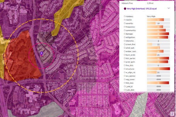
Using these factors, the model creates unique fireshed polygons across the United States, each with its own risk score. Plus, it provides detailed information at the address level, including proximity measurements to help understand the specific risk to individual structures.
Wildfire Risk Extreme
Wildfire Risk Extreme is a companion to Wildfire Risk, designed to help you understand the impact of severe wildfire conditions across the U.S. It takes into account crucial factors like fuel moisture, temperature, humidity, and wind dryness and directions, all key factors in creating extreme fire weather. These factors are essential in predicting fast-spreading wildfires that can ignite urban fires, also known as urban conflagrations.
This tool provides a comprehensive wildfire hazard and risk assessment across the country, detailing extreme burning conditions and predicting where urban conflagration can occur. It delivers actionable information for any location in the U.S. under extreme weather conditions.
Usage
- Assess wildfire risk exposure using a model that uniquely addresses the varying characteristics of each landscape
- Maximize your bottom line by avoiding high risk areas while identifying pockets of opportunity in generally risky areas
- Understand wildfire risk at the property level rather than a macro region and price business accordingly
- Measure a property’s proximity to features that mitigate risk
- Visualize wildfire risk with complete transparency into the final ratings and aggregated at the FireShed level for all 50 states
Details
- Wildfire Risk and Wildfire Risk Extreme provides scores for the following wildland fire environments:
- Wildland risk (low structure density areas)
- Intermix risk (moderate density community areas)
- Interface risk (high density city areas)
- Provides a wildfire model for all 50 states that scores the risk profile of every location from 0-50
- Includes a geo-enrichment file which appends all wildfire risk information to every affected address location using a unique identifier
- Contains proximity measurements for added insight at the address level
- Includes a supporting layer of recent wildfire perimeters
- Delivers supporting layers of all intermediate data used to generate the final ratings
Specifications
- Update Frequency
- Quarterly, Annually
- Coverage
- United States
- Unit of Sale
- Country, State