Precisely Expands Data Integrity Suite with New AI Agents for Enhanced Data Quality, Data Enrichment, and Location Intelligence Read Press release
Census Boundary Bundle – Canada
Census Boundary Bundle - Canada represents complete hierarchies of political and census boundaries for Canada. The standard version is updated every 5 years following the new Canada census, while the enhanced version is updated quarterly and includes selected large water features and more detailed shorelines.
Coverage
Canada
Product Family
Boundaries
Usage
With complete census boundary data for Canada, you can accelerate analysis and visual representation within mapping applications across a variety of use cases:
Conduct land use and demographic studies to inform marketing and planning
Perform social, economic, and market research to optimize location and network planning
Link census data to geographic areas with unique identifiers to streamline analysis
Create new geographic areas for analysis and territory management
Census Boundary Bundle (Canada) includes the following levels:
Provinces/Territories: all 10 provinces and 3 territories
Census Divisions: counties, regional districts, regional municipalities, and united counties
Census Metropolitan Areas/Census Agglomerations (CMA/CA): urban areas with populations over 100,000
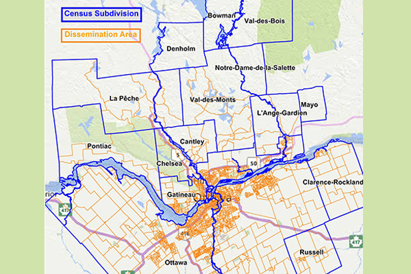
Census Subdivisions: towns, cities, villages, townships, and Indian Reserves
Census Tracts: small communities (average population 4,000)
Dissemination Areas (DA): The smallest boundary for which Canada census data is provided, with populations from 400-700 persons
Aggregate Dissemination Area (ADA): a new boundary feature created to offer a contiguous, nationwide boundary layer, based on census tracts, census subdivisions, or dissemination areas