
Ground Level Images
- Ground Level Images delivers recent, high-resolution exterior photos of commercial buildings with structured metadata and unique identifiers, enabling faster property assessment, risk evaluation, and scalable, data-driven workflows.
Coverage
- United States
Product Family
- Places
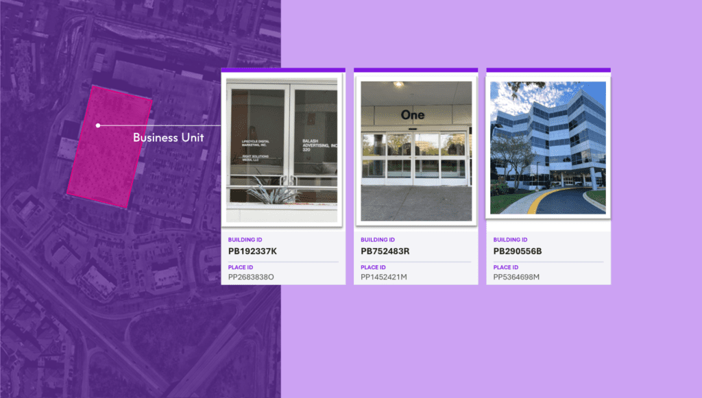
Ground Level Images delivers recent, high-resolution exterior photos of commercial properties, captured on demand and paired with structured metadata and unique identifiers. Enabled by DoorDash Tasks, it gives you a fast, scalable way to get ground-level building visuals without coordinating site visits or managing fragmented photo vendors.
With this imagery, you can quickly assess property conditions, validate risk, support underwriting decisions, and inform site planning — all from a single, standardized source that integrates directly into your data workflows.
Each image comes with structured metadata and is linked through a unique identifier, making it easy to connect to location, property, and business datasets from Precisely and from data providers in the Data Link partner program. Ground Level Images is also designed to power AI and agentic AI workflows, supplying structured visual property data that supports automated analysis and scalable operational decision-making.
Use Cases
Ground Level Images supports a wide range of use cases, including:
- Insurance underwriting: Quickly assess exterior property condition and risk indicators to support underwriting decisions without waiting for on-site inspections.
- Real estate and PropTech: Review current building conditions for due diligence, asset condition assessments, portfolio monitoring, and investment decisions.
- Retail site evaluation: Verify storefront condition, assess site characteristics, and validate locations for expansion, remodel, or merchandising decisions.
- Telecommunications network planning: Confirm building context and site conditions for network deployment planning and prioritization without requiring field visits.
- Utilities field planning: Validate site conditions for infrastructure planning and reduce rework in field operations workflows.
Details
Each Ground Level Images delivery includes:
- High-resolution exterior photo
- A recent, standardized exterior photo of the requested commercial property, captured through the DoorDash Tasks network.
- Structured metadata
- Semantically rich descriptions and labels associated with each image, making it easy to search, understand, and use in AI, analytics, and operational systems.
- Unique identifier (PreciselyID)
- Each image is linked to Precisely’s unique identifier, enabling seamless connection to property, location, business, and consumer datasets from Precisely and Data Link partners — without manual data stitching.
Features
- On-demand capture: Imagery is captured in partnership with DoorDash Tasks network, providing fast turnaround for specific commercial building locations across select places in the U.S.
- Standardized deliverables: Consistent photo sets across orders make it easy to compare properties, monitor changes over time, and build repeatable workflows.
- Analytics- and AI-ready metadata: Structured metadata is designed for enterprise integration, AI readiness, and governance from the moment it’s delivered.
- Industry-leading interconnectivity: The PreciselyID enables direct linkage to an ecosystem of pre-linked, complementary datasets from Precisely and its Data Link partners.
- U.S. availability: Ground Level Images is currently available in select places in the United States for site selection, underwriting, portfolio monitoring, and other property-centric workflows.
Specifications
- Update Frequency
- On-demand
- Coverage
- In select places in the United States
- Unit of Sale