Business leaders have long understood the value of data analysis, especially when it comes to understanding consumer behavior and driving key decisions around marketing, retail site selection, and more. Location and many of the attributes surrounding location can provide essential context to information about consumers and their behavior.
Much of the available data concerning location is aggregated based on well-defined geographies such as municipal or political boundaries. These are based on formal definitions such as city, state, or voting district. These kinds of delineations, along with things like postal codes, area codes, and census blocks can be extraordinarily useful for certain purposes. Sometime, though, data analysis calls for a different perspective on boundaries that can shed more light on the characteristics of a neighborhood, school district, or metro area.
For some situations, it can be useful to aggregate and analyze data built around socially relevant boundaries such as a broad metro area (e.g. greater Los Angeles), a neighborhood (e.g., New York’s Greenwich Village or San Francisco’s Mission District), or even individual housing subdivisions and school districts.
Unfortunately, many of these socially relevant geographies can be difficult to define, given the datasets with which most organizations are working. Socially relevant boundaries simply do not align with established municipal borders, zip codes, or census blocks in most cases. They do, however, more accurately align with consumer behaviors in most cases. As a result, the value of viewing data through the various lenses of different types of boundaries can be immense.
Boundary data adds context
Imagine that you work for an insurance company and are responsible for developing risk assessment criteria for homeowner policies. You already know that location matters. The proximity of fire hydrants or other water sources, as well as the distance from the nearest fire station, have a direct impact on the risk profile of a particular property. Likewise, homes within areas that frequently experience hurricanes are more likely to be damaged by severe weather events. These have been established criteria for assessing risk for many years.
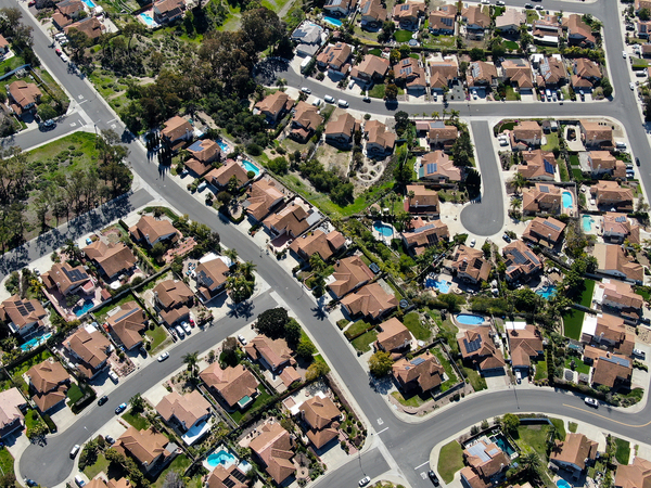
But what if you could have a better understanding of the construction characteristics of homes within a particular neighborhood? In many areas, homes are clustered into subdivisions that share many common characteristics, including construction materials, design, and workmanship. By better understanding correlations across those kinds of bounded geographical areas, insurers can refine their estimation of risk for homes within areas that have similar characteristics.
Many of the most relevant characteristics associated with location simply do not correlate well with formal municipal or census block boundaries. Crime data, for example, can vary widely from one neighborhood to another, even between areas that are very close together geographically. Precisely uses sophisticated algorithms to calculate a crime data score down to the level of an individual address. That information, in turn, can be aggregated for any bounded area defined by Precisely’s parameters.

This can be extraordinarily useful in understanding the characteristics of a given neighborhood. Consider, for example, how Manhattan is divided into well-defined neighborhoods, each with its own unique character. Populations with common interests and psychographic profiles tend to aggregate within those neighborhoods, so the ability to aggregate data at a neighborhood level can be vitally important when determining where to locate a retail store, for example.
To make matters even more challenging, such neighborhoods often go by different names or variants of a name, including foreign-language versions and abbreviations. Precisely’s boundary data definitions address those kinds of challenges seamlessly by defining a range of pre-defined bounded geographies that lend themselves to improved data analysis.
Details matter
Precisely has collected and curated a rich body of information organized around a persistent and unique identifier called the PreciselyID. Unlike many other data providers, Precisely’s information is proprietary and is validated and updated frequently to ensure accuracy.
In addition to the previous example regarding crime data, we can also score neighborhoods (or any other area defined by boundaries) based on their walkability. The walkability score is built upon an algorithm that factors in the complexity of intersections, the types of roads, the existence of points of interest, and so on. Naturally, businesses seeking to open a new retail space will place a high value on the walkability of an area. If we combine that score with other information about the characteristics of the population in the neighborhood such as income, employment, age, and lifestyle interests, we can develop a much richer understanding of our prospective customers.
This information gains even greater value when we apply further context about consumers and consumer behavior. Precisely can add more context to your existing information about consumers, not only including where they live, for example, but also where they work and spend their leisure time. For instance, understanding the income levels of an area’s daytime population (based on the inflow of workers on weekdays, for example) can be an important factor when selecting a location for a new restaurant.
Weather information provides another example of the richness of context that boundary data can provide. While we commonly think of weather patterns as being common to entire regions, there are specific characteristics associated with narrowly defined areas, each with its own micro-climate. In coastal areas or other locations characterized by high winds and tidal patterns, there can be dramatic differences in the impact of severe weather events. For insurers, that kind of information provides obvious value in terms of understanding a property’s risk profile. For other businesses such as home-improvement companies, generator manufacturers, or disaster cleanup and restoration services, this type of boundary data may also provide insight as to which customers should be targeted with marketing campaigns.
As a leader in geospatial data, Precisely understands the tremendous value that location information brings to decision-makers. We are proud to offer the most extensive portfolio of location data in the world, together with a suite of data management, data integration, and data quality products that help our customers to gain richer insights for better business decisions.
To learn more about new alternatives to capture consumer segments based on locations that transcend traditional ZIP Code and/or census boundaries, check out our on-demand webinar, Connecting Global Boundaries and Demographics.