
StreetPro™ Discover
- StreetPro™ Discover makes it easy to surface and understand street segment data. Designed for AI, it transforms street segments into semantically rich, human-readable data objects, which enables you to ask LLMs questions like “Which streets in this suburb have high traffic exposure?” and immediately get the information you need.
Coverage
- United States
Product Family
- Streets
Usage
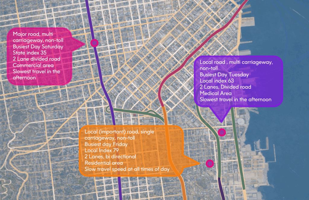
StreetPro™ Discover is purpose-built for use with LLMs and other AI systems. It groups and transforms complex street segment attributes and modelled data, typically captured as numerical values and non-descriptive fields, into human-readable text such as, “busiest hour of the week” or “Road_Type” that both people and AI can easily search, understand, and use. Unlock the full value of street data in your AI tools and easily enhance your business-critical data. StreetPro Discover™ directly supports:
- Conversational AI Interfaces: Power natural language queries, like “What might make deliveries to addresses on this street complex?”
- RAG Pipelines: Use human-readable field names and descriptions to fuel semantic retrieval and context-aware generation.
- ML Feature Engineering: Add 30+ street-level features to your data, identifying correlations with outcomes, like delays and customer churn.
With StreetPro™ Discover, you can quickly uncover and leverage location-specific information to make more informed decisions across a variety of use cases, including:
- Asset and infrastructure management: Plan and optimize investments with a clear understanding of key street attributes, like the number of lanes.
- Site selection: Identify ideal locations with street segment data that enable you to easily assess address-specific traffic volumes and street details.
- Risk assessment: Enhance underwriting accuracy with a complete understanding of the streets and traffic conditions near a property.
StreetPro™
Discover
StreetPro™ Discover is available as a TXT dataset with pipe-delimited values and provides street segment midpoints. It does not include street centerline geometries. StreetPro™ Discover also provides:
- Address-level snapshots: StreetPro™ Discover includes left/right address ranges, locality-postcode pairs, and connects street segments to a pre-linked network of data associated with addresses—such as property details, demographics, and place information—via Data Link for TomTom.
- Accelerated spatial analytics: Data is aligned to the Uber H3 Hex model (level10), enabling faster, scalable spatial operations using precise areas at the hex level.
- Diverse deployment options: Use StreetPro™ Discover in the cloud platform of your choice (e.g., Snowflake), as a flat file on premises, or in the Data Integrity Suite.
- Transactional data delivery: Accelerate analysis and gain insight into a specific location via individual transactional data rather than analyzing complete area data.
Specifications
- Update Frequency
- Quarterly
- Coverage
- U.S.
- Unit of Sale
- Country, Transactional